
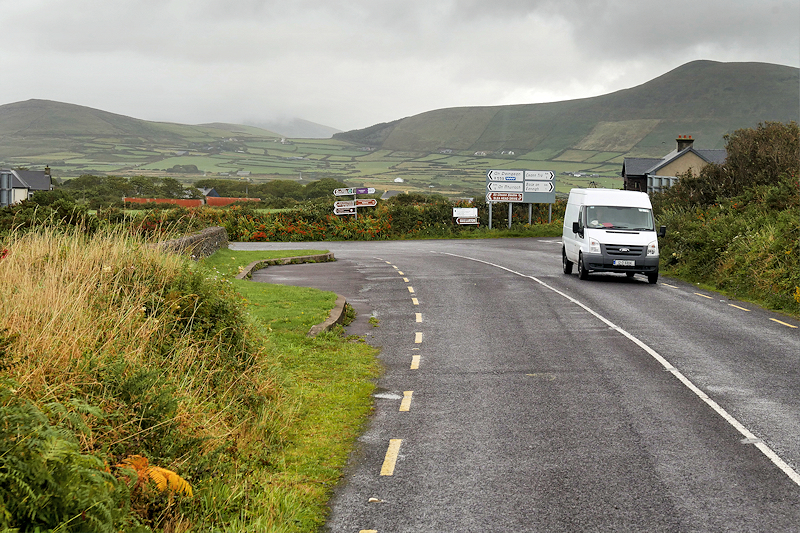
The Slea Head Drive is a 30-mile loop west of Dingle Town that circles the tip of the Dingle Peninsula, tracing narrow roads past Iron Age forts, Early Christian beehive huts, and some of the most jaw-dropping coastal scenery in Ireland. It’s technically part of the Wild Atlantic Way, but this loop deserves a full day on its own.
The road hugs clifftops above the Atlantic, winds through Irish-speaking villages, and passes working farms where stone walls have stood for centuries. You’ll drive counterclockwise from Dingle, and you’ll want to take your time.
The Route: Dingle to Slea Head and Back
Start in Dingle Town and head west on the R559 toward Ventry. The first stretch is gentle—rolling green fields, whitewashed cottages, and Ventry Strand, a wide crescent of sand that’s popular with surfers and families. Pull over at the beach for a first look at Mount Eagle rising ahead.
Past Ventry, the road narrows and climbs. You’ll pass Dunbeg Fort, a 2,500-year-old stone promontory fort perched on a cliff. It costs around $5 to enter, and the views alone are worth it. The walls are intact, and you can walk the ramparts above the crashing waves.
Further west, you’ll reach the Fahan group of beehive huts—clocháns—dry-stone structures built by early Christian monks. Several clusters line the road; the most accessible is just past Dunbeg. Expect to pay a small access fee ($3–5) to the landowner. These huts are the real thing, not reconstructions, and stepping inside one is like crawling into history.
Slea Head itself is the westernmost point of the loop, marked by a small parking area and a lookout over the Blasket Islands. The Great Blasket, the largest, was inhabited until 1953 and produced some of Ireland’s most celebrated Irish-language writers. On a clear day, the view stretches to the Skelligs.
What to Stop For Along the Way
After Slea Head, the road turns northeast along Dunquin and Ballyferriter. Stop at the Blasket Centre in Dunquin—a small museum dedicated to the island’s history and literature. It’s well done, with exhibits on island life and the writers who chronicled it. Entry is around $6.
In Ballyferriter, Tigh Bhric is a blue-painted pub serving excellent seafood chowder and brown bread. It’s a local favorite, and you’ll likely hear Irish spoken at the bar. The village also has a small heritage center and a few craft shops.
As you continue east toward Murreagh and Gallarus, watch for signs to Gallarus Oratory, one of the best-preserved early Christian churches in Ireland. Built sometime between the 6th and 12th centuries, it’s a small, boat-shaped stone structure with a corbelled roof that still keeps out the rain. There’s a visitor center nearby, but you can view the oratory itself for free from the adjacent field.
The final stretch of the loop runs inland through Kilmalkedar, where a 12th-century Romanesque church and an alphabet stone sit in a quiet graveyard. From there, it’s a short, scenic drive back into Dingle Town.
Driving Tips and Timing
The Slea Head loop is a narrow, winding road—often single-track with passing places. Drive slowly, pull over for oncoming traffic, and expect tractors, sheep, and tour buses. Go counterclockwise (the direction described here) so you’re on the inside lane for most of the coastal views.
The full loop takes 90 minutes if you don’t stop, but plan on at least four hours to visit the sites and pull over for photos. If you want to linger, budget a full day and add a walk on Ventry Strand or a detour to Coumeenoole Beach, a stunning, sheltered cove near Slea Head.
Summer brings the most traffic, especially tour buses in the afternoon. Early morning or late afternoon offers quieter roads and better light for photography. Winter is dramatic—wild seas and moody skies—but some small sites may be closed, and weather can turn quickly.
Where to Eat and What to Bring
Pack snacks and water—there are no cafés between Ventry and Ballyferriter. Dingle Town has plenty of places to stock up before you start: Heaton’s Guesthouse does a good takeaway breakfast, and the SuperValu on Main Street has sandwiches and coffee.
For lunch, Tigh Bhric in Ballyferriter is your best bet on the route. If you’re back in Dingle by evening, Out of the Blue serves the best seafood in town—no reservations, cash only, and they close when they run out of fish.
Bring layers and rain gear. The weather shifts fast on the peninsula, and even in summer, the wind off the Atlantic is bracing. Good walking shoes are useful if you plan to explore the forts or beehive huts.
How to Get There
The loop starts and ends in Dingle Town, about 30 miles west of Tralee and 50 miles from Killarney. If you’re driving from Killarney, take the N22 west, then the N70 and R561 over the Conor Pass (or the longer, easier R559 via Annascaul if the pass is closed in bad weather).
You’ll need a car. Viator runs guided coach tours from Killarney and Tralee, which cover the loop and include stops at the major sites, but driving yourself gives you the freedom to stop where you want and skip the crowds.
There’s no public transport around the loop itself, and bike rental is an option only if you’re fit—it’s hilly and exposed.
The Slea Head Drive is one of those rare routes that lives up to the hype. Every turn delivers another postcard view, and the history is layered into the landscape like the stones in a clochán wall. It’s Ireland at its most elemental—ancient, Atlantic, and utterly unforgettable.
Want one story a day about Ireland’s roads, ruins, and hidden corners? Subscribe to The Ultimate Ireland Travel Guide newsletter.
Heads up — some links in this article are affiliate links. If you sign up through them, we may earn a small commission at no extra cost to you. We only recommend tools we use ourselves.