
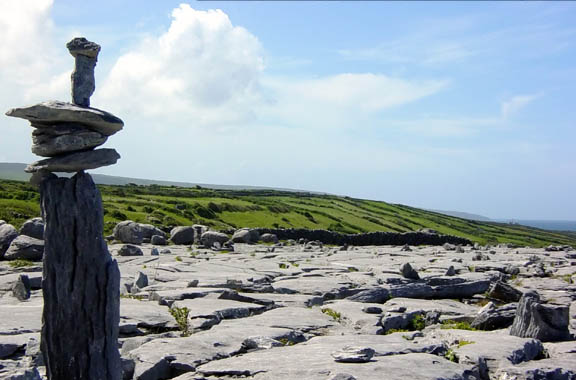
The Burren doesn’t look like the rest of Ireland. Instead of green fields and hedgerows, you’ll find a moonscape of cracked gray limestone stretching across 100 square miles of northern County Clare. It’s stark, strange, and completely captivating—a place where Arctic, Alpine, and Mediterranean plants grow side by side in the cracks, where underground rivers vanish into the rock, and where Stone Age tombs rise from the pale stone like ancient sentinels.
This is one of Ireland’s most unique landscapes, and it rewards slow exploration. Give yourself at least a full day, ideally two, to understand what makes this place so different.
The Poulnabrone Dolmen and Ancient Sites
Start at the Burren’s most famous landmark: the Poulnabrone Dolmen, a portal tomb dating back more than 5,000 years. The thin capstone balanced on two upright slabs looks impossibly fragile against the surrounding limestone pavement. It sits just off the R480 between Ballyvaughan and Kilfenora, with a small car park and boardwalk access.
Arrive early in the morning or late afternoon to avoid tour buses. The site is free and always open, but the real experience comes from the surrounding landscape—walk a few hundred yards in any direction and you’ll have the limestone terraces to yourself.
The Burren holds more than 70 megalithic tombs, along with ring forts, stone churches, and holy wells. The Caherconnell Stone Fort, a restored Iron Age ring fort near Poulnabrone, offers guided tours and sheepdog demonstrations. Entry is around $8, and it’s one of the few places where you can walk inside a fully intact cashel.
Walking the Green Roads and Trails
The best way to see the Burren is on foot. The region’s old “green roads”—ancient pathways that cross the plateau—are now maintained walking trails threading through the limestone.
The Burren Way is a 71-mile waymarked trail from Ballyvaughan to Lahinch, but you don’t need to walk the whole thing. The section from Ballyvaughan to Doolin (roughly 22 miles) covers the heart of the plateau and can be broken into day hikes. The stretch from Fanore to Black Head offers coastal views on one side and limestone hills on the other.
For a shorter walk, try the Caherconnell Loop (3 miles) or the trail to Turlough Hill from the Burren Centre in Kilfenora (2.5 miles). Both give you limestone pavement, wildflowers in late spring and summer, and wide views across the plateau.
Wear sturdy boots—the rock is sharp and uneven. Bring layers even in summer; the plateau is exposed and the weather changes fast.
What to See Beyond the Stone
The Burren’s limestone holds surprises. At Mullaghmore, the highest point in the region at 630 feet, you’ll find terraced pavements carved by glaciers and a summit with views across Galway Bay to Connemara. The walk from the small car park on the Corkscrew Hill road takes about 30 minutes each way.
In wet weather, seek out the turloughs—seasonal lakes that appear and disappear as the water table rises and falls through the porous rock. The turlough near Carran is one of the most reliable, filling in winter and draining by summer to leave a grassy basin.
Visit the Aillwee Cave near Ballyvaughan for a look at what lies beneath the surface. Guided tours (around $18) take you through caverns carved by an ancient river, past frozen waterfalls of calcite and the bones of long-extinct brown bears. The adjacent Birds of Prey Centre offers hawk and owl demonstrations if you have time.
Don’t miss the Burren Perfumery in Carran, where they distill wildflower essences and offer free garden tours showing the plateau’s impossible botanical diversity—gentians, orchids, and spring gentian growing inches apart in the grikes (the deep cracks between limestone slabs).
Base Towns and Practical Tips
Ballyvaughan, on the north coast, makes the best base—a small harbor village with good pubs, cafés, and several B&Bs. Linnane’s Lobster Bar serves fresh seafood right on the pier. Kilfenora, on the southern edge, is smaller but closer to the Cliffs of Moher and has the excellent Burren Centre museum ($7 entry), which explains the region’s geology and archaeology.
The Burren sits between Galway (30 miles north) and Ennis (20 miles southeast). You’ll need a car to explore properly—the sights are spread out and public transport is limited. The main routes are the R477 coastal road from Ballyvaughan to Fanore, the R480 across the plateau, and the twisting Corkscrew Hill road that climbs from Ballyvaughan toward Lisdoonvarna.
May and June are the best months for wildflowers. The limestone holds heat and drains quickly, creating micro-climates where rare plants bloom weeks earlier than elsewhere in Ireland. September offers clearer skies and fewer visitors.
Set aside time to simply stop and walk onto the limestone. The Burren doesn’t reveal itself from the car—you need to get out, step onto the rock, and look closely at what grows in the cracks.
Want more stories like this? Subscribe to The Ultimate Ireland Travel Guide newsletter and get one short story a day—real places, practical tips, and the Ireland beyond the guidebooks.