
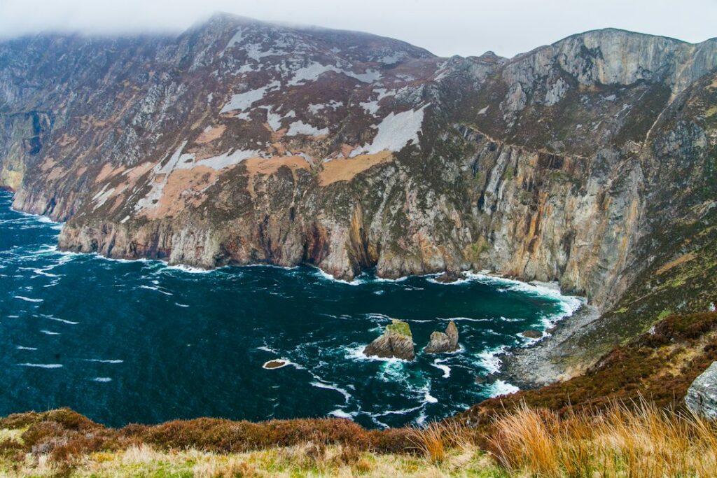
At nearly 2,000 feet, Slieve League rises three times higher than the Cliffs of Moher. The sea cliffs in southwest Donegal are among the highest in Europe, and the hike to the summit offers one of Ireland’s most dramatic coastal walks. You’ll find sheep-dotted slopes, vertiginous drops, and views that stretch from Sligo Bay to the mountains of Mayo — often with only a handful of other walkers in sight.
Donegal doesn’t pull the tour bus crowds that Kerry and Clare do, which means Slieve League remains wonderfully quiet even in high season. If you’re looking for a big coastal hike without the selfie sticks, this is it.
How to Get to Slieve League
Slieve League sits about 90 minutes west of Donegal Town and just over three hours from Galway or Sligo. The nearest village is Carrick, a tiny place with a couple of pubs and not much else. From Carrick, follow signs for Teelin, then take the narrow road up to Bunglass, the main viewpoint and trailhead.
The road to Bunglass is steep, single-track, and not for nervous drivers — but it’s paved and well-maintained. There’s a small car park at the top (free) and a visitor shelter with information boards. If you’re not confident driving narrow mountain roads, you can park in Teelin and walk up, adding about an hour each way.
No public transport runs here, so you’ll need a car or a tour. Viator offers guided day trips from Donegal Town and Sligo that include Slieve League, often paired with stops in Glencolmcille or along the coast.
The One Man’s Pass Trail
The classic Slieve League hike follows the ridge from Bunglass to the summit, crossing a narrow section called One Man’s Pass. The full loop is about 6 miles and takes four to five hours, depending on pace and weather. It’s not technical, but it is exposed — the path runs along the cliff edge with steep drops on both sides.
Start at Bunglass and follow the well-worn trail west along the ridge. The views open up immediately: the Atlantic below, the Sligo mountains to the south, and on clear days, the peaks of Achill Island and the Twelve Bens in Connemara. The path climbs steadily, passing old watchtowers and stone walls before reaching One Man’s Pass, a knife-edge ridge about three feet wide with 1,600-foot drops on either side.
If you’re comfortable with heights and the weather is calm, it’s thrilling. If not, there’s a bypass path that skirts below the ridge — it’s longer but much less exposed. From the pass, it’s a short climb to the summit at 1,972 feet, marked by a cairn and a trig point.
The return follows the same route, or you can descend via the Pilgrim Path, an old track that drops down to Teelin. The Pilgrim Path is easier on the knees but adds mileage if you’ve parked at Bunglass.
When to Go and What to Bring
Late spring through early fall offers the best conditions — longer daylight, drier trails, and wildflowers on the slopes. Summer brings the calmest weather, but even then, winds can gust hard on the ridge. Check the forecast before you go, and don’t attempt the hike in high winds, fog, or rain. The exposure on One Man’s Pass makes it genuinely dangerous in poor conditions.
Wear sturdy hiking boots with good grip — the path is rocky and uneven, and sections can be slippery after rain. Bring layers, a windproof jacket, water, snacks, and a hat. There’s no shelter once you leave the car park, and the wind can be fierce even on sunny days. Sunscreen and sunglasses are essential; the light off the Atlantic is intense.
Start early if you’re visiting in summer — the car park fills by midday, and you’ll want time to take your time on the ridge. Sunrise hikes are spectacular if you’re up for the early start.
Where to Eat and Stay Nearby
Teelin has one pub, Ti Linn, which serves soup, sandwiches, and hot drinks — perfect for post-hike recovery. In Carrick, try the Rusty Mackerel for seafood chowder and fresh fish. Killybegs, about 20 minutes east, has more restaurant options and is Ireland’s busiest fishing port, so the seafood is as fresh as it gets.
For accommodation, Carrick and Killybegs have guesthouses and B&Bs. Glencolmcille, a scenic valley 15 minutes west of Teelin, offers more choices, including the cozy Dooey Hostel and several self-catering cottages. Donegal Town, 30 miles east, is a larger base with hotels and restaurants, though you’ll spend more time driving.
Combine Slieve League with a drive through Glencolmcille and along the coast to Malin Beg and the Silver Strand — it’s one of Donegal’s most beautiful stretches and sees far fewer visitors than the Wild Atlantic Way highlights further south.
The Ultimate Ireland Travel Guide delivers one short story a day to help you explore Ireland beyond the guidebooks. Subscribe to our newsletter and get the best of Ireland’s landmarks, villages, hikes, and hidden corners delivered to your inbox.
Heads up — some links in this article are affiliate links. If you sign up through them, we may earn a small commission at no extra cost to you. We only recommend tools we use ourselves.